Drones
From site mapping and topographic surveys to inspection, imaging, and rapid data capture, aerial platforms have become a practical tool for engineering teams and industrial operators. Choosing the right Drones category often depends on the type of mission, the level of positioning accuracy required, flight endurance, payload flexibility, and the kind of image or measurement data you need to collect.
Within this range, users can compare compact camera drones, RTK-enabled survey platforms, and payload-ready enterprise aircraft for more demanding fieldwork. The lineup on this page focuses strongly on DJI solutions, covering workflows from visual inspection and photogrammetry to higher-accuracy mapping and airborne data acquisition.
Where industrial and survey drones are typically used
In B2B environments, drone systems are no longer limited to photography. They are widely used for land surveying, construction progress monitoring, infrastructure inspection, agricultural observation, public safety operations, and asset documentation where fast coverage and repeatable data capture are important.
For mapping and geospatial work, RTK-capable aircraft help improve positional reliability and support more consistent results in orthomosaic generation, 3D modeling, and site measurement workflows. In visual inspection tasks, multi-camera systems and stabilized imaging can help operators examine roofs, facades, towers, stockpiles, or hard-to-reach structures without direct access equipment.
Understanding the main drone groups in this category
This category includes several practical equipment profiles rather than a single type of UAV. Compact camera drones are often selected for portable field deployment, quick visual documentation, and general site observation. Enterprise models add stronger transmission, mission-oriented control features, and better integration with professional workflows.
Another major group is survey and RTK drones, designed for positioning-sensitive tasks such as mapping, corridor documentation, and terrain modeling. There are also payload-capable drone platforms that support specialized sensors or gimbals, making them suitable when users need more than standard RGB imaging.
Representative DJI drone options for different workflows
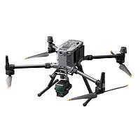
For teams that need a modern enterprise imaging platform, the DJI Matrice 4E Drone offers a combination of long flight time, multiple cameras, and high-precision positioning support. That makes it relevant for inspection, documentation, and mapping-oriented missions where operators benefit from both wide coverage and the ability to capture more detailed views from a distance.
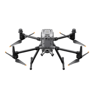
The DJI Matrice 350 RTK Drone is better aligned with users who need a more robust airframe, longer endurance, and support for heavier or multiple payload configurations. In geospatial and industrial projects, this type of platform is commonly considered when flexibility, environmental resilience, and integration with advanced sensors are important.
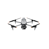
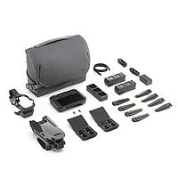
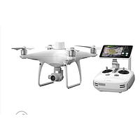
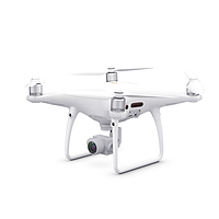
For smaller and more portable operations, DJI Mavic 3 Camera Drones can fit workflows that prioritize mobility and high-quality visual capture. Legacy and established platforms such as DJI PHANTOM 4 RTK Camera and video equipment or DJI Phantom 4 Pro V2.0 Quieter Flight and Updated Transmission System may still be relevant for teams familiar with those ecosystems or maintaining continuity with existing operating procedures.
When payload and sensor compatibility matter
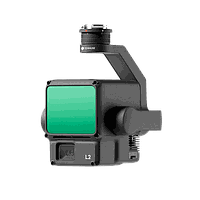
Not every drone project is centered on the aircraft alone. In many industrial applications, the real value comes from the sensor payload carried by the platform. A model such as the DJI Zenmuse L2 Digital Camera (58 W) illustrates this clearly, as payload compatibility can define whether a system is suitable for advanced mapping, 3D data capture, or specialized inspection workflows.
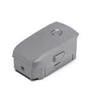
Accessories also play a practical role in keeping field operations moving. For example, the DJI Mavic 2-pin Mavic 2 Enterprise Battery (3850mAh / 59.29Wh) is the type of support component that affects uptime, mission planning, and battery rotation strategy, especially for teams operating on remote sites or under tight inspection schedules.
Key selection criteria before buying a drone system
For technical buyers, comparing drones should go beyond headline flight time. Start with the mission objective: visual inspection, mapping, public safety observation, or payload-based sensing. Then evaluate whether the aircraft supports the right camera configuration, navigation method, environmental protection level, communication range, and control interface for your field conditions.
It is also useful to consider how the drone fits into the wider measurement ecosystem. If the project combines airborne surveys with ground-based motion or positioning tools, related instruments such as speed sensors or Doppler radar may complement the overall data collection strategy, depending on the application.
- Portability and deployment speed for field crews
- RTK or high-accuracy positioning needs
- Payload support for specialized cameras or sensors
- Flight endurance and battery management planning
- Wind resistance and protection level for outdoor work
- Transmission reliability in complex environments
- Output data type: imagery, video, 3D data, or measurement support
Operational considerations for professional users
Industrial drone deployment usually requires more than simply selecting an aircraft. Buyers should think about pilot workflow, spare batteries, charging logistics, transport cases, controller type, and how captured data will be transferred into CAD, GIS, inspection, or reporting systems. These details often have a direct impact on productivity in the field.
Communication and coordination may also be relevant on larger sites, especially when multiple teams work across wide areas. In those cases, equipment such as walkie-talkie systems can support safer and more organized operations during aerial missions, inspections, or survey campaigns.
Choosing the right drone for survey, inspection, or imaging work
A compact model is often the right starting point for routine imaging and mobile field documentation. An RTK platform makes more sense when positional consistency and mapping output are central requirements. A larger enterprise airframe becomes the stronger option when users need extended endurance, better environmental tolerance, or compatibility with advanced payloads.
That is why this category is best approached as a set of workflow-driven options rather than a simple list of flying cameras. By matching aircraft class, sensor capability, and operational demands, buyers can narrow the selection to a drone system that supports both present project needs and future expansion.
FAQ
Are all drones suitable for surveying?
No. Basic camera drones can support visual documentation, but surveying and mapping tasks often benefit from RTK capability, consistent flight planning, and data workflows designed for measurement accuracy.
What is the difference between a camera drone and an enterprise drone?
A camera drone is typically chosen for imaging and portability, while an enterprise drone may offer stronger control features, higher resilience, payload support, and better suitability for professional inspection or survey operations.
Why are accessories important in drone operations?
Batteries, chargers, controllers, and payload components affect mission duration, readiness, and the types of tasks the drone can actually perform in the field.
Whether the priority is portable aerial imaging, RTK mapping, or a more advanced payload-ready platform, this category gives professional buyers a focused starting point. Reviewing the intended workflow first will make it easier to select a drone system that fits your accuracy needs, field conditions, and long-term operating model.
Get exclusive volume discounts, bulk pricing updates, and new product alerts delivered directly to your inbox.
By subscribing, you agree to our Terms of Service and Privacy Policy.
Direct access to our certified experts